It's included a db with points used in the loop writed above and same db file used for the map layout Rember to insert db connection data in the file to include in the script header named 'database.php' and a pin image like 'pins/single.png'
<?
include "database.php"; $dataQuery = date("Y-m-d");
$result = mysql_query("SELECT * FROM INPUTDATA where data > $dataQuery");
?>
<!DOCTYPE html PUBLIC "-//W3C//DTD XHTML 1.0 Transitional//EN" "http://www.w3.org/TR/xhtml1/DTD/xhtml1-transitional.dtd">
<html>
<head>
<title></title>
<meta http-equiv="Content-Type" content="text/html; charset=utf-8">
<script type="text/javascript" src="http://dev.virtualearth.net/mapcontrol/mapcontrol.ashx?v=6.1&mkt=it-IT"></script>
<script type="text/javascript">
var map = null;
function GetMap()
{
map = new VEMap('myMap');
map.LoadMap();
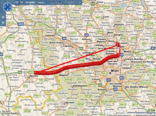
var locs = new Array;
var pinid=0;
<?$count=0;
while ($row = mysql_fetch_array ($result, MYSQL_BOTH))
{
$dataH = date("d-m-Y H:i:s",strtotime($row['data']));
echo "
var loc = new VELatLong(".$row['latitudine'].",".$row['longitudine'].");
locs.push(loc);";
if ($invia != "Nascondi dettagli")
{echo "
var pin = new VEPushpin($count, locs[$count], 'pins/single.png', 'Device $row[id_device]',
'Data ora: $dataH <br>Stato $row[state] <br>Number $row[number] <br>Car $row[car] ');
map.AddPushpin(pin);";
}
$count++;
}
?>
var options = new VERouteOptions();
options.RouteMode = VERouteMode.Walking;
map.GetDirections(locs, options);
}
</script>
</head>
<body onload="GetMap();">
<legend>Mappoint</legend>
<div id='myMap' style="position:relative; width:800px; height:600px;"></div>
<?
mysql_close ($connection);
?>
</body>
</html>
|